
Important:
Please note this is a working farm not a tourist venue. Remember there is no right of access.
Bywood farm history and field boundary survey
The history of Bywood (Bivde, Biuuode, Bywud, Byewood)
Bywood, is situated in the Hundred of Hemyock in east Devon, is suggested to be one of the recorded Domesday holdings. Here, it’s earliest spelling Bivde: bi being beside, suggesting ‘beside the wood’. DB also states that prior to 1086 Queen Matilda held the lands of Bivde - (Thorn and Thorn eds. 1985, DB, 24, 1). This is perhaps the earliest documentary evidence for a Saxon period land holding established at the location known today as Bywood. Domesday also lists Bivde (Bywood) as being held by Walter of Claville from the King. The chief-in-tenant of -Biuuode (Bywood) can be recognised in the Tax returns for the Hemyock Hundred and states that the Abbot of Dunkeswell holds it from John de Clavill and by him from the Honour of Gloucester (FA Vol 1, PRS. 1C 338, Thorn and Thorn eds. 1985, DB notes, 24, 1).
Charters dated 13th April 1206 confirm that in 1201 William de Brewer gave the lands of Dunkeswell manor to the Cistercian monks in order ‘to build an Abbey of the Cistercian order in the Manor of Donkewell from the convent of Forde’ (transcripts of the WWII destroyed Monasticon Dioecesis Exoniensis, in Style & Style 1996, Vol. 1, part 1, 28). The same Charter informs that Richard de Hydon’s gift of Bywood lands to Ford Abbey are validated as a gift from Ford to Dunkeswell ‘the abbot and convent of Ford the entire right that the same abbot and convent have had in Biwode’ (Bywood). In fact the holdings of Dunkeswell Abbey during the 13thcentury were numerous within the Hemyock Hundred and included Dunkeswell itself;Waringstone (Weston) Bolham, Bywood, Stentwood and Wolford, and Awliscombe (FF1nos. 283, 297, 541, Fees, P. 1443; Rot Ch pp. 164-5 in Summerson, 1985: 21). Neighbouring Bowrehayes and Gorwell in Hemyock, were also former granges of the Abbey, as was Wolveston (Wolverstone) in Awliscombe and Shapcombe in Luppitt held in the Axminster hundred (Youing, 1955: 131 m.14). After the death of the Abbot of Forde a second Charter dated 20th February 1227 was created to confirm Dunkeswell Abbey holds Bywood (Style & Style 1996, Vol. 1, part 1, 28). The 30th May 1244 saw the Abbot of Dunkeswell forced to surrender a 40-acre moiety of Bywud and Bolham to Richard de Hidon, which de Hidon then re-conveyed back in exchange for orisons (DFF 1, p.285). Feudal Aids for 1284-1286 shows the abbot of Dunkeswell holds Biuuode (Bywood) from John de Clavill, and that the abbot of Dunkeswell still retains Bywode (Bywood) into the 14th century with further references in 1303 and 1346 (Vol 1, PRS. 1C pgs. 338, 367, 430).
The Valour Ecclesiasticus of Henry VIII shows Bywood Grange as a holding of ‘D’abbi’a de Dunkeswell (Vol II, 304). After the Dissolution in the 16th century the large estate of the Dunkeswell Abbey was divided and its pieces either sold or held by the Crown. Besides the manor of Dunkeswell and the site of the abbey itself, the Granges of Bowerhayes (neighbouring Bywood directly to the west) and Bywood were also sold (Youing, 1955: 131 m.14). Devon Monastic Lands; Calendar of Particular for Grants 1536-1558 records the Crown held Bywood until 4th July 1539 when it then became the property of John Lord Russell (Youing 1955: 7 pg. 4).
The next recording here leaps to discuss the 19th century ownership. Here the Tithe Survey lists the landowner of Bywood farm and its’ land holdings, as Elizabeth Simcoe. The Simcoe family estate is Wolford in the south of the parish, and as a result of taking possession of much of the former abbey holdings they held much of the Titheable area in the parish of Dunkeswell. Other than the retention by Elizabeth Simcoe of the woodland (see Woodland management below), it is a Henry White who sits as tenant in Bywood renting and working the courtlage, buildings and the majority of the land.
Boundary Survey
The community Landscapes Project carried out a boundary survey of Bywood
Farm, Dunkeswell. These page contain the results of the field and boundary
survey. The rest of the report then sets out a hypothetical model to
demonstrate a likely scenario for the development of the Bywood fields.
Bywood in the 1st half of the 19th century stood as 320 acres of arable, pastoral and woodlands.
The starting point is therefore the 19th century Bywood holdings, since this is pre-
mechanisation. Fieldnames are mostly taken from a single source Fieldnames
by J. Fielding 1993
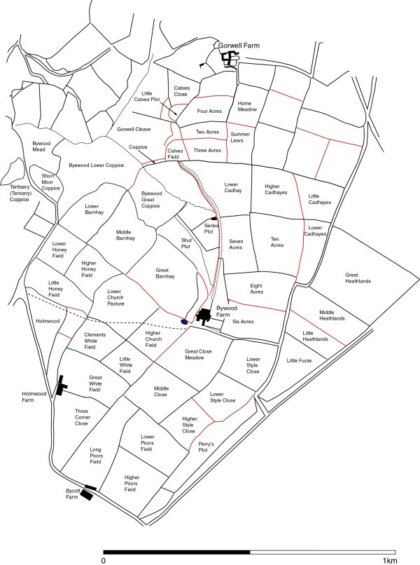
Fig. 10: Shows the layout of fields for Bywood and Gorwell as seen on the 19th Century Dunkeswell and Hemyock Tithe Maps with lighter lines denoting the field boundaries that are now lost. Included are the Tithe Apportionment field names. Their block-like application can be seen to follow each successive intake of land.
Note: Although present here Holmwood and Bycott are both farms that were not established until the 20th
Century.
Ownership of the land in and around Bywood farm has changed somewhat over the
last 150 years. The western and southern extents, having originally been part of the early 19th
century Bywood Grange as seen on the 1844 Dunkeswell Tithe Map (TM), now belong to Bycott
and Holmwood farms. However beside the inception of these two post 19th century farms, early 19th
century Bywood’s field pattern has remained relatively un-changed over the last 150 years and can
still be easily traced. In fact a documentary trawl revealed no Parliamentary Enclosure Awards
for the land associated with, or surrounding, Bywood farm.
Field Boundary Survey method
All areas are different. This survey takes in the different styles of build found on in this area of the Blackdown Hill. Whether this type system can then be applied elsewhere has yet to be determined.
The system used was very simple. The only measurements taken into account were the bottom width and the top width. Height and volume was not necessarily a factor here. This meant that very old, but poorly-maintained hedges could in effect regain there original status.
Description of hedge structure
Type 1 = 1m x 0.50m Dry stone walls with central earth in-fill only. Scrub vegetation.
Type 2 = 1.5m x 1m All of these boundaries still stand 1m or more. The structure is mainly earth with poor quality hedging stone, topped with irregular scrub/thorn vegetation.
Type
3 = 2m x 1.5m All well-constructed and sizeable structures As above topped with irregular scrub/thorn vegetation but with various established large tree types.
Type
4 = 3m x 2.5m As above all well constructed and sizeable structures only wider than type 3.
Type
5 = 3m x 2.5m Very substantial structures. Earth & stone matrix, topped with various irregular types thorn/scrub and established tree types well-established established large tree.
Type
6 = 3.5m x 3m Very substantial structures. Earth & stone matrix, topped with irregular thorn/scrub but with well-established large tree types
Type
7 = 4m x 3.5m Very wide double-hedged structure with possible ditches on topside. Eroded earth & stone matrix topped with double line of well-established large tree types with clear signs of past coppicing along the full length. Possible to walk centre passage.
Type
8 = 4.5m x 4m As above with type 7 but wider. The centre passage being wide enough to easily walk standing upright if not walk two abreast.
Table Above: Shows the formula applied during the field boundary survey. For the sake of constancy the same two people worked together and carried out all hedge measurement. Neither height, nor volume was considered since many of the hedges were relicts (see fig 10).
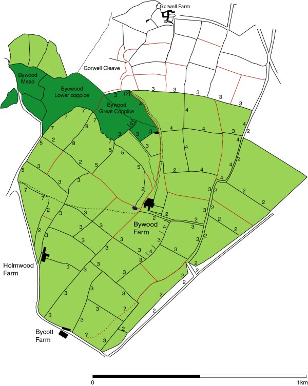
Fig 11: The results of the field boundary survey. The lighter line colour traces lost hedge lines that could not be recorded.
Discussion
Although there are a total of eight field boundary types used in the field boundary survey, the overall results suggest this can be broken down into three main areas of change. This is not to state that there were only three endeavours to construct enclosures, but rather three areas of distinct change. There are no neat patterns of change but a certain degree of crisscrossing and areas of total transformation, but all three areas retain some elements of previous work.
The area of slender-hedged, post-medieval, type 2 hedges (for examples of
late-enclosure seediscussions by Aston 1985, 131-7, or Hoskins 1992, 156-61) sits quite separated
from the main holdings and contains fieldnames, e.g. Furze and Heathland, that infer this was once
moor land (see map above). Suchstyle of enclosure was probably as a result of local agreement on the
enclosure of part of Luppitt Common. Being adjacent to identified areas of late Iron age/early
Romano-British activity; especially iron workings these areas may well have been involved in the
extensive Late-Iron Age woodland clearance. By undertaking clearance they would have provided
themselves with land for agriculture and fuel for general use and charcoal for the production of
iron. This in turn could aid the explanation for the presence of the feature 3
(see Iron Workings reports) on the top flat plateau rather than on the hill
slope. The presence of hedging characteristic of 19th century enclosure in and around the farm
buildings however upholds the buildings survey (carried out by the Blackdown Hills Rural Partnership)
which suggests the farm buildings, as they stand today, date from the very late 18th or early 19th
century.
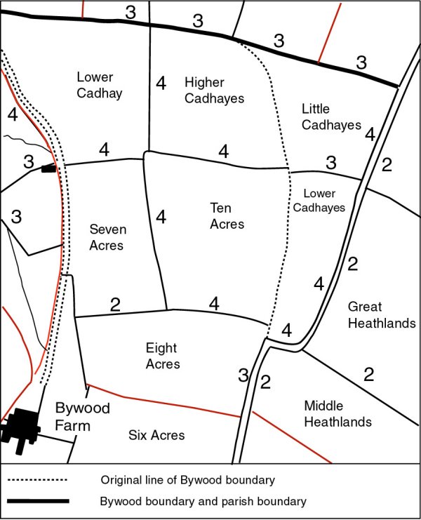
The area of enclosure with ‘Acre’ (typical late enclosure fieldname) and ‘Cada’ (medieval/old English personal name also seen in places such as Cadbury) fieldnames is an area that has seen at least two periods of major changes. The 18th/19th century changes to the farm buildings layout (or wholesale relocation) has resulted in fields such as Six, Eight and Seven Acre, having probably lost more substantial type 3 or 4 hedges and seen replacement by type 2 and perhaps alteration in the fieldnames. Certainly the hedges of Ten Acre appear to be the oldest surviving, which were then enwrapped by the creation of the fields holding Old English Cada names. One event may directly have followed the other since all the hedges are of similar build. In the case of Little and Lower Cadahayes they appear as an extension of the actual Bywood holdings, albeit one earlier than the foundation of the road. Furthermore the parish boundary follows the northern edge of all these fields suggesting they pre-date its setting. That Gorwell’s lobe-shaped arable field system, suggested here to have been the result of ploughing from the 10th century and fixed by the beginning of the 13th century, abuts this boundary suggests it pre-dates the field layout of Gorwell.
Area of early medieval field names surround the site of a Late-Iron Age - Early Romano-British farmstead/Iron working? enclosure (see enclosure report).
The pattern of enclosure within the southern part of Bywood is quite different.
Here its possible to see a distinctive pattern of enclosure starting from the west and moving east
ending with the Stylefields (or perhaps Stile, a right of way leading on to the common as shown by
the present day path). The pattern of enclosure here certainly doesn’t have the systematic ridged
layout of late 18th-19th century enclosure and the size of the hedges are substantially bigger than
those normally recorded in late enclosure. Some of the hedges, such as the west side of Lower
Church (Church fieldname is probably as a result of this being the direction
taken when walking the right of way to church ), do show curvature in their layout that may hint at
enclosure of medieval ploughing, but overall they are fairly formal in there layout. Interestingly the fieldnames
suggest 13th to the 18th century enclosures. Therefore the suggestion here is type 3 and
4 enclosure could fall anywhere within the rather wide 14th to the 17th century. It should
be noted however that within the areas of Cadhayes fields and the Honey
(note: Honey in this case meaning sticky clay soil) fields some boundaries show signs of
even earlier layout. Looking at the ownership it is interesting to note that during this period the
Dunkeswell Cistercian monks,who are renowned for changing the landscape, are for most of this period
hold the lands of Bywood. Then again the majority of fieldnames and lack of small irregular fields
may forewarn of later 16th century enclosure reform started perhaps when John Russell gained the
holdings of Bywood.
The very largest enclosure boundaries sits atop the headland to the west of the modern day Bywood farm buildings. These boundaries are quite different in their build from all those mentioned before since here the hedges are in the main double-banked, some with ditches and central passages bringing to mind the sort of 7th century boundary described by Hoskins (1983,
figs & 10).
At Bywood however, there are two different sized double-banked boundaries enclosing two areas of different size that overlap. Today the largest of these boundaries (4.5 m wide) is almost levelled but still divides Lower Barnhay
(Barn fieldnames meaning is probably place of farm building) from Middle Barnhay, but this present-day use may belie its true intention. This hedge links to a boundary that ran down through the woodland, up to where medieval Gorwell abuts it. The boundary runs on dividing Little and Lower Cadhayes from the main Bywood holdings, and can then be shown by the line of the encircling road and track looping around back through Holmwood, between Lower and Higher Honey fields to rejoin where it started. This boundary which even encloses the majority of 19th century Bywood contains several different types of hedge category but overall shows a major rebuild using
type 3 and 4 design. It is possible this heavily reworked encircling boundary once set the limits of early medieval Bywood.
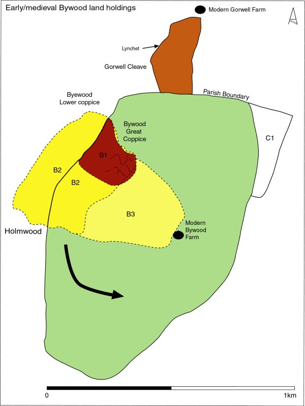
Figs. 13: Bywood in the early medieval period.
B1 is the area of small enclosures
possibly prehistoric field system or a set of early medieval enclosures around an early medieval
Bywood. Although the eastern extent of
B2 has a boundary type 5 (possible later rebuild) this is the area suspected as
having once been enclosed by the double-banked boundary
type 7. B3 is an extension of B1 & B2 eventually seeing the whole of this headland enclosed by substantial enclosing boundaries. The most substantial double-banked boundary, type 8,
however is shown cutting across the lobe-shaped enclosure and denotes the outer enclosure of the
greater Bywood holdings. Both of these enclosures may likely have existed at the same time but for
different reasons. C1 like the western extent of B2 may be an early extension/assart of the original Bywood land holdings. Finally the
arrow denotes the direction taken by later enclosure.
The only ground outside is the late-enclosure, woodland and areas B2 and
C1 (see fig. 13 above). Whilst both C1 and B2 contain
Old English fieldnames, B2 is also encircled a second time by another major
double-banked hedge system. It is possible both C1 and B2 are early Saxon period
extensions/assarts of the original Bywood land holdings. In the case of the
B2 area this would have pushed the holdings out to encompass all the level land on the
headland. Such a move would explain why a type 3 or 4 didn’t replace the only
surviving type 8 hedge; it simply wasn’t required and therefore took on a new role as a basic
field divide. This new slightly smaller double-banked enclosure however encloses
B2 an area on the top of the headland, which interestingly incorporates the area denoted as
B1. This is an area recorded as that of possible small square enclosures. These could be
prehistoric field systems or a set of early medieval enclosures around an earlier medieval Bywood.
Although the eastern extent of B2 has a boundary type 5 this has been explained as a
possible later reworking which may then have been extended to incorporate
B3 and thereby the rest of the flat headland.
The reason, given here, for the presence of the second smaller double-banked enclosure is quite different from enclosing a manorial holding. After discussion with the landowner/farmer it seems this headland holds the best arable land on the holdings. Just down off the steep sides of the headland was an area mostly enclosed by woodland, i.e. Great and Lower Byewood Coppice and Holmwood. Even today the hedges on the headland that abound these wooded areas are those of the double-banked type 7 and 8. It is therefore possible this was double-banked hedge simply to keep wild and domesticated animals, which would have been running loose in the woodland out of the area of top cultivatable land.
Bywood as a whole
The result of the Community Landscapes Project palaeoenvironmental research, their earthwork surveys and the resulting landscape study provides an impression of a mainly wooded landscape opened during the Late Iron Age. From this time onwards there is management of the surviving woodland in the Cleave, surrounded by a pastoral landscape on the plateau top (within present-day Gorwell and Bywood) seemingly with set areas of arable determined by the limits of good soil and level terrain. Although the pollen diagram shows increase charcoal and what appears to be managed woodland, at present there is an absence of early iron workings at Bywood. Bearing in mind the evidence for 1st century AD workings and the Blackdown Hills as a whole still lack serious archaeological attention, no doubt further research would disclose indications of early iron working activity. In fact the possible smelting area in the Late Iron Age/Early Romano-British D-shaped enclosure may well be a good place to start. Even if this feature proves not to be Late Iron Age in date excavation may reveal whether the 1st century workings are a local reaction to outside demand or the work of the Roman army.
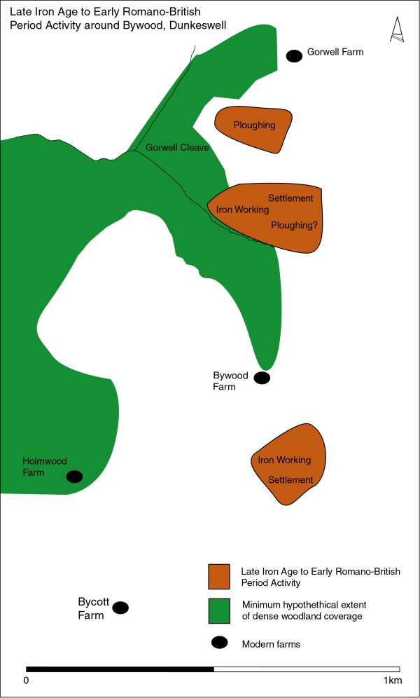
Fig. 15: Shows areas of Iron Age and Romano-British activity. All the sites sit on or close to the edge of the plateau top. Only further investigation will reveal whether the area in the centre of the plan surrounded by woodland and containing the earliest signs of medieval activity also hold signs of prehistoric activity.
Evidence for the early medieval suggests this fine balance of resource management was maintained. Woodland remained in the valley bottoms, cereal production was contained, as it always had, to small set areas of on the edge of the plateau whilst the very top was mostly an open pastoral landscape with areas of moor. Gorwell operated a degree of woodland management in the Cleave along with winter sheltering for the cattle. In the summer cattle would graze the open pasture on the plateau top separate from the crops by an outer lobe-shaped enclosure. In the same way Bywood appears to have enclosed a larger area of headland for cereal production but in this case separated it mostly from surrounding woodland with pasture off to the east. Although slightly different in layout both farms have fixed positions that ensure best use of the resources. A fixed pattern of land use, such as this, was probably a direct result of large areas of mediocre soil quality and steep topography. This would have meant the development of convertible husbandry (see Rippon 2004, 13) seen elsewhere in the South West would not necessarily have worked here. Nevertheless the lands of Gorwell and Bywood, in the latter part of the 1st Millennium, still saw an intensification of land use. If the lack of change in monetary value is accepted as no change in usage, Domesday implies little had changed by the late 11th century. Arguably the biggest internal changes came after the 13th century when the Cistercians took hold and set about enclosing the holdings or was it re-enclosing? Domesday however informs that:
Domesday Book 1086
Bywood paid tax for 3-and-a-half virgates of land. There was land for three ploughs of which 1 plough; 2-and-a-half virgates were in lordship and half a plough and 1 virgate held by 4 villagers. 150 acres of pasture (Thorn & Thorn eds. 1985, DB 24,1)
Terry Green in his MA dissertation (see bib.) uses a proposed customary range of 45-60 acres when talking about quantity of acres to the hide (and 1 virgate is considered to be equal to a quarter of a hide) for Devon. When this is applied here (14 acres to a quarter hide) Bywood consisted of 36 acres in lordship and 14 acres held by villagers giving a total of 50+or - acres of land for the plough. Is this the 60 acres enclosed on the headland? There is approximately a further 50+or- acres or 1 and half plough not taxed and therefore probably not under the plough. Is this Cada's old farm (hayes)? In addition there is 150 acres of pasture, giving Bywood a total of 250 acres of pastoral and arable land. Interestingly, given the pitfalls in attempting an interpretation of Domesday Book details, not including the obvious later enclosure or the woodland this figure matches the land holding size suggested here for earliest Bywood. This implies that although internally Bywood may have begun to receive divisions in the form of hedges the actual size of the land holdings and the boundary hedges remained roughly in the same location. Furthermore the diversity of resource use, even in the case of iron working, appears to remain the same throughout from the Late Iron Age to the Late Medieval. In fact it isn’t until the Post medieval period that an increase in the size of the holdings onto the moor is visible. Late enclosure of mid-upland open pasture matches with events elsewhere in the South West.
To conclude although distinct periods of landscaping have occurred the older layouts of Bywood and Gorwell (see report) have remained relatively intact. Within this the present-day methods of low-intensification farming have also resulted in the survival of many superb archaeological and ecological features. It is possible Bywood is a unique case however it is unlikely. The answer lies in a change in regard and expansion of archaeological research to include such rich diverse mid-uplands.