
The geology around the Fal Estuary is dominated by Devonian metasedimentary rocks, the Carnmenellis Granite to the west and the St Austell Granite to the east. The shoreline around the estuary is made up of Devonian metasedimentary rocks assigned to the Portscatho Formation, the Mylor Slate Formation and the Porthleven Breccia Member (of the Mylor Slate Formation) (Leveridge et al., 1990).
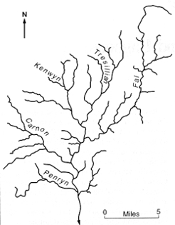
Simplified geological map of southern Cornwall. Dotted line represents the approximate catchment area of the Fal Estuary system
The Devonian (Frasnian) Portscatho Formation is dominantly composed of alternating grey or greenish grey, sandstones and mudstones (slates) along with less abundant siltstones. The Mylor Slate Formation is well developed around Carrick Roads and is dominated by dark grey slates with thin pale grey sandstones and siltstones. This rock unit is also Devonian (Famennian) in age. The Porthleven Breccia Member is included within the Mylor Slate Formation, but comprises angular fragments of a range of rock types included within mudstones. Locally igneous rocks (originally basaltic in composition, but altered during regional metamorphism to what are referred to in Cornwall as greenstones) occur in amongst the Devonian sediments. All of these Devonian rocks were folded and regionally metamorphosed during a major mountain building event known as the Variscan orogeny some 350-290 million years ago.
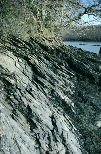
Devonian metasediments of the Mylor Slate Formation form the rocky shoreline around much of the estuary
Subsequently large granite masses were emplaced into the Devonian rocks. Two large granite bodies occur within the catchment area of the Fal Estuary; the Carnmenellis Granite to the west and the St. Austell Granite to the east. The Carnmenellis Granite is roughly circular in outline and is predominantly composed of muscovite-biotite granite. To the east of the estuary is the St. Austell Granite. This granite is composed of three main textural and lithological varieties; the eastern part is largely composed of biotite granite, whilst the western part is composed of topaz granite and tourmaline granite. The tourmaline (or lithium-mica) granite is extensively altered to kaolinite. The topaz granites occur as well defined bodies within the St. Austell Granite.
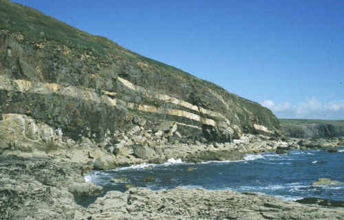
Granite sheets (pale colour) intruding dark Devonian metasediments at Megiliggar. Photograph courtesy of Robin Shail, CSM.
Associated with both the Devonian metasediments and the granites is the extensive development of mineralisation. Most of Cornwall's metalliferous mineral deposits are hydrothermal in origin; that is they formed by the precipitation of the economic minerals from hot fluids circulating through fractures in the rocks. Most commonly this fluid flow was through clearly defined fractures which form mineralised fractures or lodes. These lodes will comprise the economic ore minerals (cassiterite, wolframite, chalcopyrite, arsenopyrite, sphalerite and galena), along with uneconomic gangue minerals (quartz, tourmaline, chlorite, fluorite, siderite and calcite). These lodes dominantly trend WNW-ESE or ENE-WSW and are then cut by a later set, known as cross-courses, which trend N-S.
Throughout the Fal Estuary catchment area, the Devonian metasediments, and in part the granites, are overlain by the much younger Quaternary (last 1.6 million year old) sediments. These sediments typically comprise Pleistocene (1.6 million to 10,000 years ago) deposits which overlie raised shore platforms cut into the Devonian metasediments. The characteristic succession comprises at the base rounded pebbles and cobbles, interpreted to be raised beach deposits. These raised beach sediments, deposited during interglacial conditions are usually overlain by poorly sorted sediments, referred to as head deposits, which formed as slope deposits under periglacial conditions during the last Quaternary glacial interval (the Devensian). During the Devensian glaciation, although glaciers were not present in west Cornwall, periglacial conditions were present. Sea level would have been much lower and the large scale valley systems such as the Fal would have extended considerably further away from our present-day shoreline. These valleys would have been partially infilled by head deposits. It is also likely that large scale river systems were present at this time. These river sediments reworked mineral veins exposed at the surface and the stable resistant tin mineral cassiterite was reworked and locally concentrated within these sediments forming placer deposits (Camm, 1999 ). These placer deposits formed the tin grounds which were then worked from the Bronze Age onwards. At the end of the Devensian glaciation, sea level rose and the coastal valleys were inundated by the sea. Evidence that the landscape would have been wooded at this time comes in part from the presence of submerged fossil forests and peat beds around the Cornish coastline, including at The Moor (Falmouth) and at Maenporth. Samples from Mounts Bay have been dated at 4278 ± 50 years before present (Leveridge et al., 1990). Over the Holocene period (the last 10,000 years) sea level initially rose quite rapidly at about 1 m per century (Healy, 1999), drowning the river valleys to form the estuary; in the latter part of the Holocene the rate of sea level rise decreased to about 0.1 m per century, such that the rate of sediment supply outpaced the rate of sea level rise so that the upper parts of the estuary started to infill with sediment creating an apparent sea level fall. This type of flooded valley system is referred to as a ria, which is defined as an ‘inlet formed by partial submergence of unglaciated river valleys’, synonymous with a ‘drowned valley mouth usually with a branching dendritic or tree-like outline’ (Bird, 2000).
 |
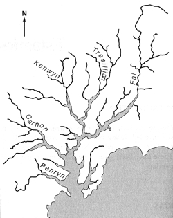 |
Diagram illustrating how the local geography of the Fal area has changed over the last 18,000 years. Back in the Devensian periglacial conditions were present and sea level was much lower. At the end of this ice age, sea level rose and the Fal valley system was flooded forming the present day estuary (Bird, 2000).
The geomorphology of the landscape around the Fal Estuary is characterised by steep sided valleys separated by gently rounded interfluves. Most of the larger towns (Truro, Falmouth, Penryn) are on the western side of the estuary whilst the eastern side of the estuary is predominantly rural in nature. The historic environment of the Fal Estuary is described in detail in the “Fal Estuary Historic Audit” published by the Cornwall Archaeological Unit in 1997.
In addition to the formation of the extensive polymetallic mineralisation, the granites of south-west England, and in particular, the western side of the St. Austell Granite have been extensively altered forming world class deposits of china clay (kaolinite). Some 150 million tonnes of china clay have been produced from south-west England (Bristow, 1998) and consequently the industry has had a huge environmental impact. The china clay deposits were formed through the kaolinization of granites, during which in the presence of water the feldspars in the granite are altered to kaolinite. This was a two stage process involving both the initial circulation of hydrothermal fluids followed by intense chemical weathering at a later date (Bristow, 1998).