

Important Disclaimer : The locality information is for reference purposes only. You should never attempt to visit any sites listed on this site without first ensuring that you have the permission of the landowner for access and that you are aware of all safety precautions necessary. Many localities are Sites of Special Scientific Interest and damaging the site is prohibited. We will not be held responsible for any action taken against you or any accident incurred.
A code for geological fieldwork is provided by the Geological Society at this link
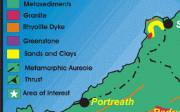
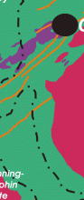
Within an area of the orefield it is possible to see either geological exposures illustrating the host rock geology, granite-dyke intrusions, metamorphism, structure and mineralization, Quaternary geology and mining landscapes. By clicking onto the starred sites below you can visit the locations.
Below the map are other virtual field excursions in PDF format.
|
||||||||||||||||||||||||||||||||||||||||||||||||||||||||||||||||||||||


Other virtual geological field excursions in PDF files are for:
West Penwith, (2.83MB)
Marazion to Porthleven, (1.22MB)
Porthleven to Polurrian, (0.67MB)
The Lizard, (2.11MB)
St Austell Area, (1.40MB)
East Cornwall, South Devon and Dartmoor. (1.73MB)
Geodiversity of selected quarries in Cornwall
For the geodiversity of selected quarries in Cornwall visit Part 1 South (2.72MB) and Part 2 North (1.64MB) .
This project has received support from ASLF Partnership Grant through Defra's Aggregates Sustainability Fund.
Further information on quarrying and related learning resources
Please visit Virtual Quarry, QuarryEd, Good Quarry or Quarry Products Association
This site was last updated on
Saturday, February 3, 2007 8:22 PM
.
Webmasters : Simon Camm & Paul
Hedley